Position: Master’s Capstone Project
Organizations: Wetzin’wka Community Forest, Silvicon Services
Using LiDAR data and tree-level growth modelling to design a thinning prescription that balances ecological resilience, cultural foraging access, and economic sustainability.
About the Forest
Wetzin’kwa Community Forest (WCF) is a ~33,000 hectare forest tenure co-managed by the Town of Smithers, the Town of Telkwa, and the Wet’suwet’en First Nation. Located on the Yintah (traditional territory) of the Wet’suwet’en peoples, the forest contains a mix of harvestable timber stands, cultural heritage sites, and areas dedicated to recreational use. Its management is guided by five values: Cultural, Economic, Ecological, Recreational, and Community.
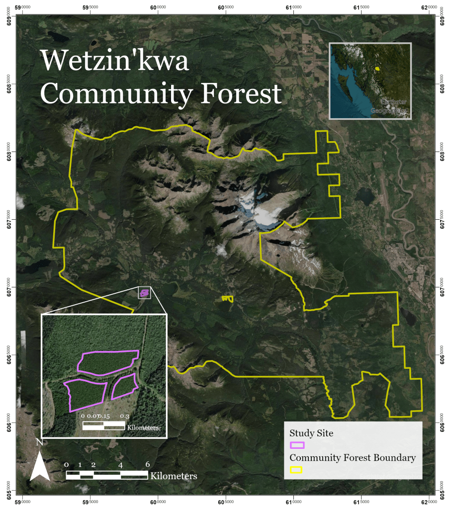
Wetzin’kwa Community Forest boundary and study site location within the tenure
Multi-Objective Thinning
Thinning is a silvicultural treatment that selectively removes trees from a stand to reduce competition and improve conditions for the remaining trees. Historically, thinning has been applied primarily as an economic tool – however, it also offers a range of ecological benefits. By opening the canopy and reducing stand density, thinning can promote understory biodiversity, increase wildlife habitat, and lower susceptibility to wildfire and disease.
Despite this potential, designing a single treatment that meaningfully advances multiple objectives simultaneously remains underexplored in the literature.
This project aimed to develop a thinning prescription for Wetzin’kwa Community Forest that balances ecological, cultural, and economic values, within one management scenario.
| ECOLOGICAL • Create habitat for ungulates and other wildlife • Improve understory health and diversity • Increase resilience to wildfire and disease | CULTURAL • Increase huckleberry growth and fruit production • Enhance community access to non-timber forest products | ECONOMIC • Increase stand health and timber quality • Reduce cumulative mortality • Increase resilience to wildfire and disease |
Methods
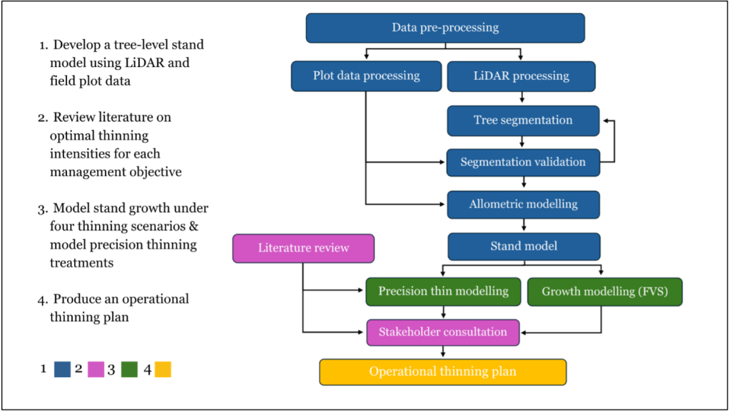
Building a tree-level model of the stand
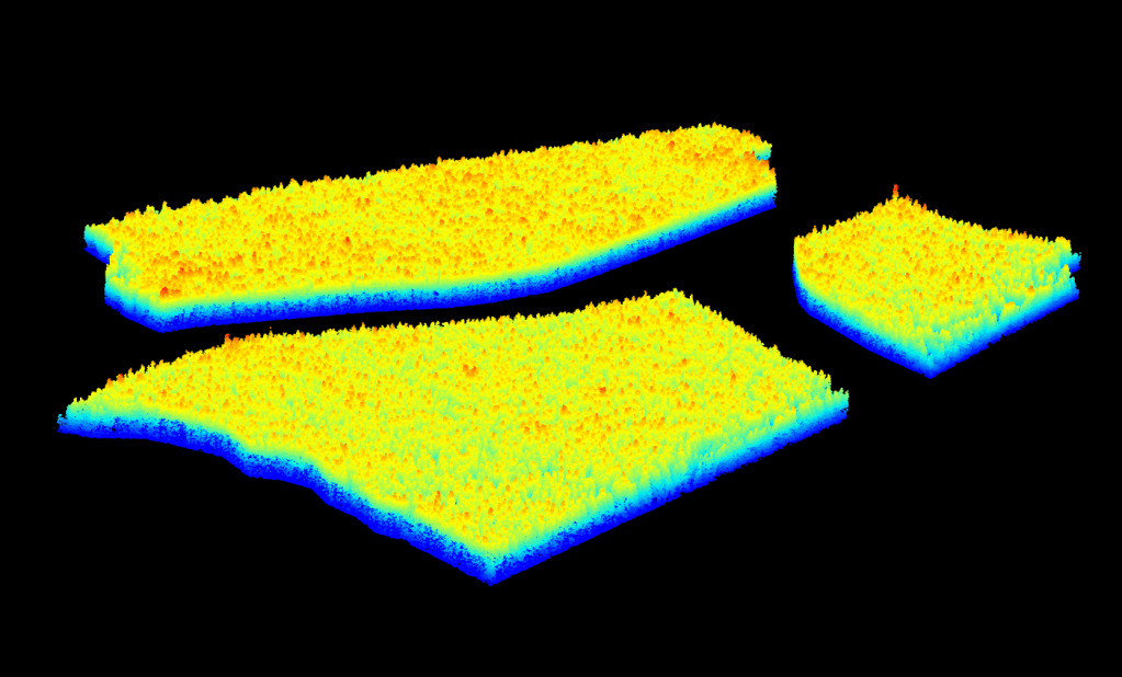
Airborne LiDAR data was first processed into a Canopy Height Model (CHM). From the CHM, individual trees were detected and segmented using the Dalponte 2016 algorithm in the lidR package in RStudio. The algorithm works in two stages: first, local maxima are identified across the CHM as candidate treetops; then, each detected treetop is used to seed a segmentation that delineates the crown boundary of that tree.
Code snippet
#=====================================# IMPORT LIDAR DATA#=====================================#import lidar datalas_data <- readLAScatalog("Data/Lidar") #Optional: check lidar data and view CRSlas_check(las_data)st_crs(las_data) #===================================================#CONVERT CRS and CLIP LAZ FILES TO AOI#===================================================#clip .las data to the roilas_clipped <- clip_roi(las_data, stand_kml_converted)#create a DEM using the tin() algorithmdem <- rasterize_terrain(las_clipped, 0.5, tin())#=======================================================#NORMALIZE HEIGHTS AND FILTER OUTLIERS #=======================================================#normalize the data using DEMlas_norm <- normalize_height(las_clipped, dem)#filter undesired data pointsrange(las_norm$Z, na.rm = TRUE)las_norm<- filter_poi(las_norm, Z >= 0 & Z <= 20)#======================================#CREATE CHM#======================================#create simple CHM with a 0.5m resolution using p2r CHMchm <- rasterize_canopy(las_norm, res = 0.5, algorithm = p2r(0.15))plot(chm)#apply a small mean smoothing filterchm_smoothed <- terra::focal(chm, w = matrix(1,3,3), fun = mean, na.rm = TRUE)#=======================================# TREE DELINEATION AND CROWN SEGMENTATION#=======================================#define a variable window size f <- function(h) { pmax(1.0, pmin(6.0, 1.5 + 0.05 * h))}#locate tree topsttops <- locate_trees(chm, lmf(f)) plot(chm) plot(ttops, add=TRUE, col="red")#segment treescrowns_dal <- segment_trees(las_norm, dalponte2016(chm_smoothed, ttops, th_tree = 6)) plot(crowns_dal, color = "treeID")
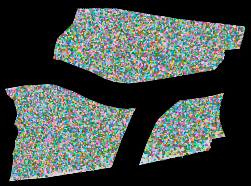
Post-segmentation stand model. Every detected crown is individually delineated and attributed with LiDAR-derived height and crown area.
The segmentation was then validated against plot level data by comparing the number of segmented trees to the trees recorded in cruise data counts. A total of 16,998 individual trees were detected and segmented from LiDAR data across the study site. Overall segmentation performance was high, with recall rate of 87%, a precision of 100%, a commission error of 0% and an omission error of 13%.

Example of individual tree segmentation accuracy within the boundary of plot-level field data, overlaid on the canopy height model.
Plot-level field measurements were used to fit predictive models estimating tree attributes across the stand. These models generated stand-wide predictions of DBH, crown diameter, and basal area for each segmented tree, enabling detailed structural mapping at the individual-tree scale.
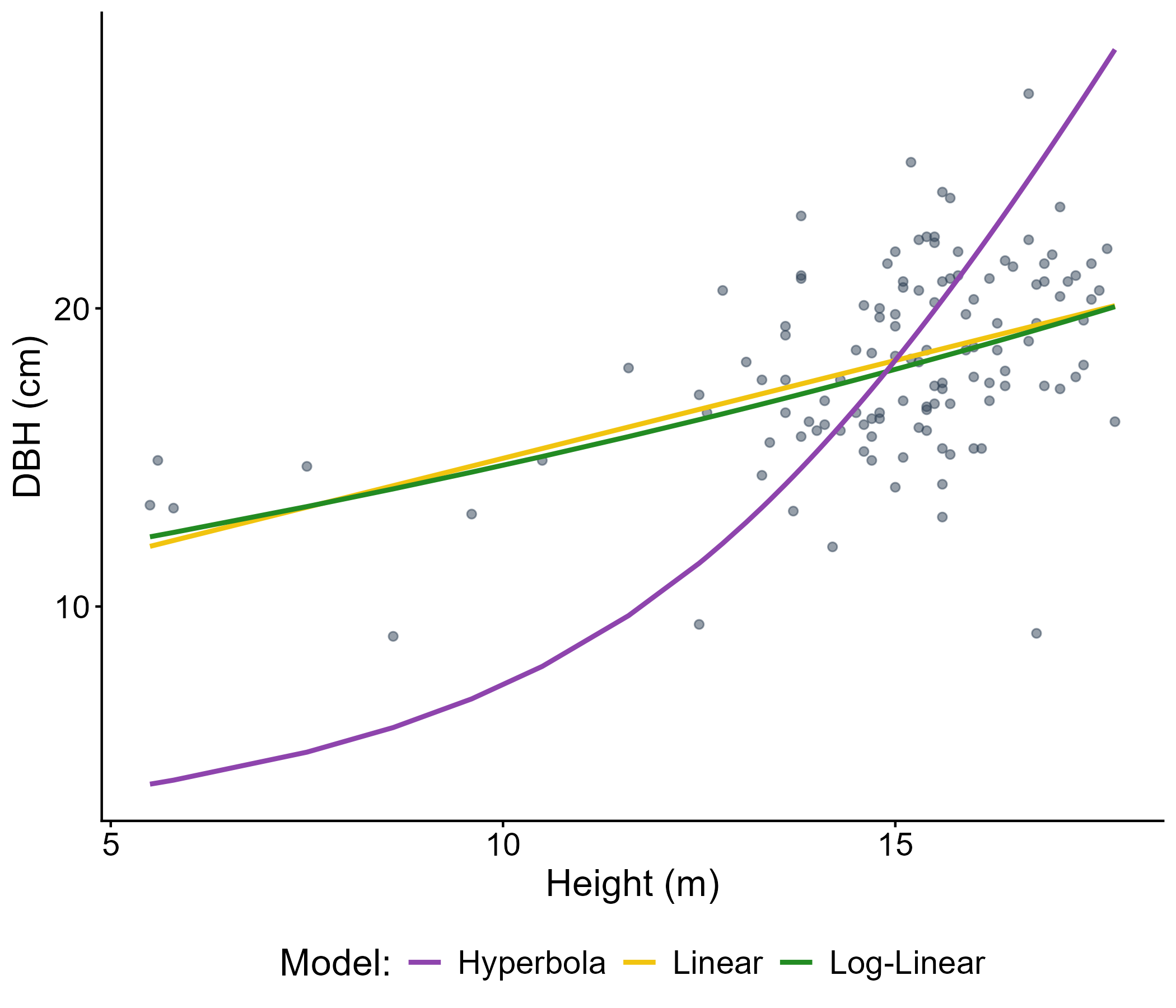
Comparison of three regression models fitted to plot-level data used to predict tree attuites across the stand.
Modelling stand growth in FVS
With a complete tree-level dataset established, growth and yield responses were modelled in the Forest Vegetation Simulator (FVS). Four management scenarios were projected 40 years into the future: no intervention, and 20%, 30%, and 40% basal area removal using a thin-from-below technique.
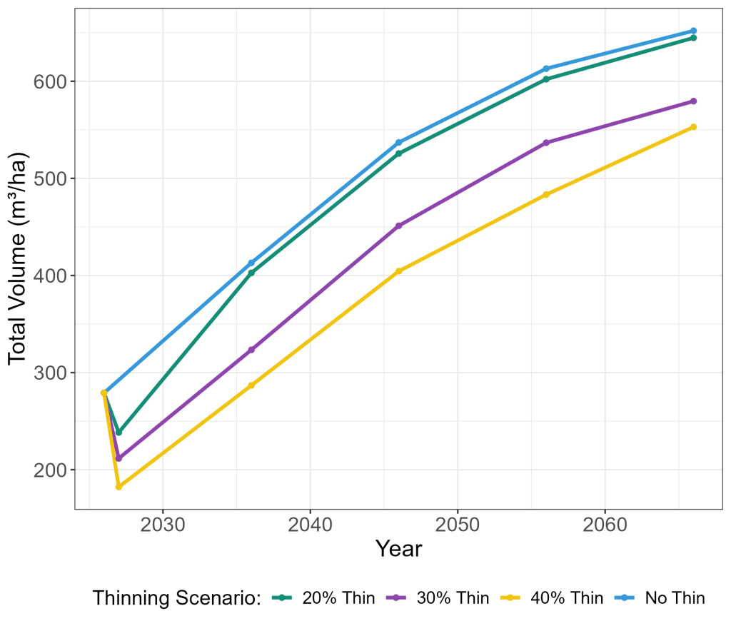
Total stand volume was compared between treatments, in addition to Cumulative Merchantable Volume (total merchantable volume removed during the thinning + total merchantable volume at the end of the growth model). Other metrics such as Mortality and Quadratic Mean Diameter (QMD) were also compared.
Selecting a thinning prescription
A targeted literature review was conducted to inform thinning objectives and operational parameters. The review focused on four primary objectives: (1) enhancing wildlife habitat and understory biodiversity, (2) improving growing conditions for huckleberry (Vaccinium spp.), (3) reducing wildfire and forest health risks, and (4) addressing operational and regulatory constraints.
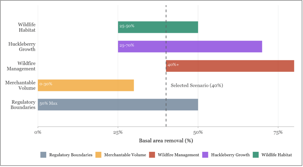
Light to moderate thinning (20-30%) increased total merchantable volume. 40% removal produced marginal volume reduction but significantly decreased cumulative mortality.
Moderate to heavy thinning (25-50%) increased wildlife habitat use and understory diversity, huckleberry productivity peaked at 25–75% removal, though heavy soil disturbance negatively impacted fruit production.
Heavy thinning (40-80%) reduced wildfire risk, contingent on surface fuel treatment.
Variable Density Thinning
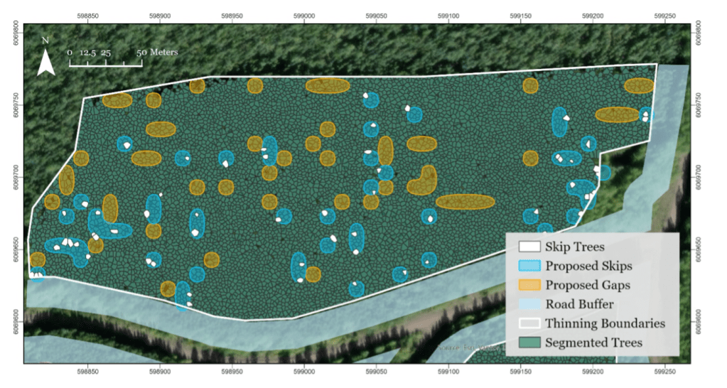
Variable Density Thinning (VDT) deliberately creates structural heterogeneity by mixing areas of heavy removal (gaps), protected retention (skips), and standard even thinning to produce a more ecologically complex and resilient forest. The northern portion of the study site was designated as an area to implement VDT treatment.
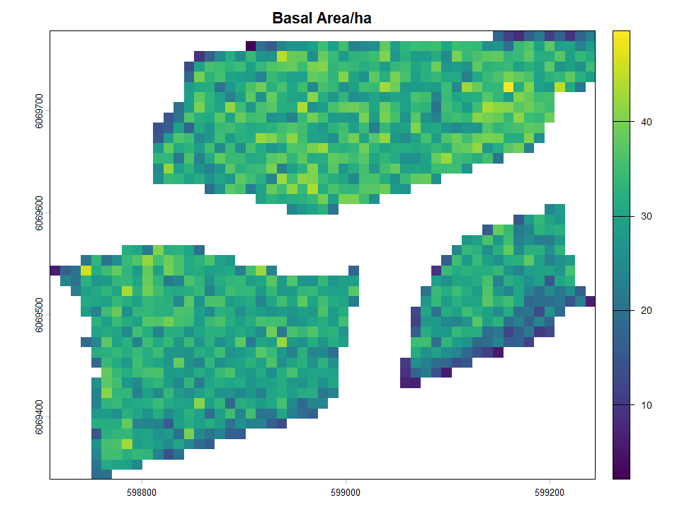
A 10 × 10 m management grid was overlayed to divide the stand into cells. Grid-level basal area, stem density, and canopy cover were calculated to understand and visualize stand heterogeneity.
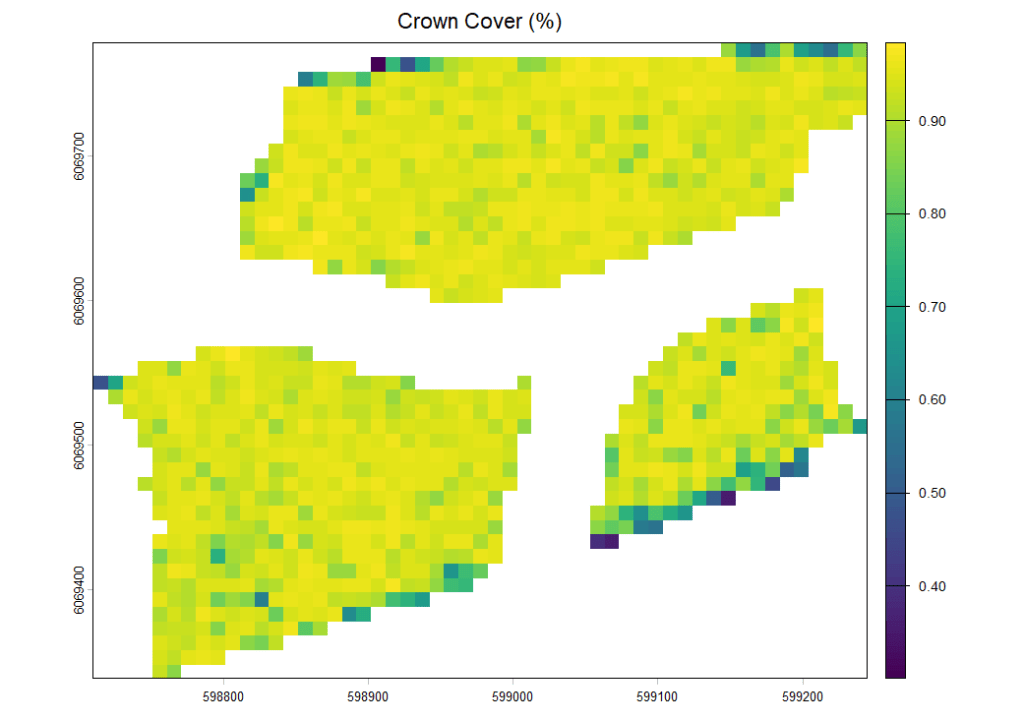
Skips areas were designated around trees in the 99th height percentile, as the tallest and likely healthiest trees in the stand area form important habitat structure.
Gap areas were identified by targeting the lower 30th percentile of basal area and stem density, and the lower 50th percentile of canopy cover, selecting the most structurally suppressed and light-limited areas.
Putting it together: the operational thinning plan
The final step was to integrate the many components of this project (tree-level data, FVS scenario outputs, gridded stand metrics, skip and gap polygons, and operational constraints), into a spatially explicit thinning plan in ArcGIS Pro.
Two access path scenarios were modelled to reflect different equipment configurations. Scenario 1 assumed 5 m-wide access trails spaced at 15 m intervals, meeting standard machinery width and harvesting reach requirements specified by the provincial thinning guidelines. Scenario 2 assumed a narrower 3 m path width, reflecting more maneuverable equipment as specified by Silvicon Services.
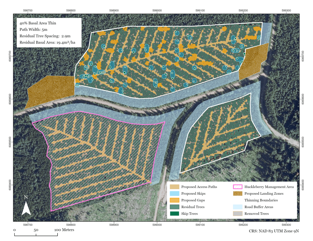
Operational plan for scenario 1: 5m wide harvesting equipment with pre-designated access paths and 15m spacing between paths. 40% basal area removal, with variable density thinning implemented in the northern section of the stand.
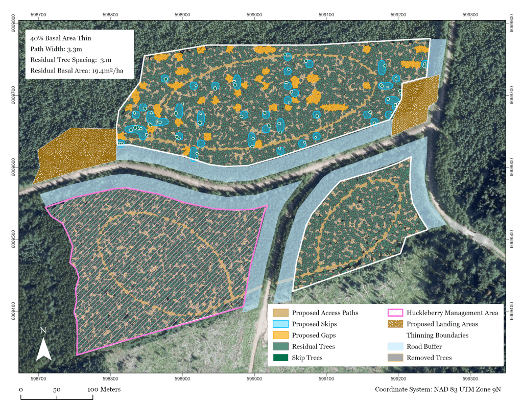
Operational plan for scenario 2: 3m wide harvesting equipment with operator-guided movement prioritized throughout the stand. 40% basal area removal, with variable density thinning implemented in the northern section of the stand.
Conclusion
The central finding of this study is that ecological, cultural, and operational thinning objectives are not fundamentally conflicting. While some studies identify significant trade-offs between timber and biodiversity objectives in boreal forest thinning context, the objectives examined here proved largely complementary at a moderate basal area removal intensity. A moderate prescription was sufficient to theoretically advance habitat creation for ungulates, huckleberry growth potential, and wildfire risk management without imposing prohibitive operational constraints or significant economic costs. The small reduction in total merchantable volume identified through FVS growth modelling represents the primary trade-off, although the small decrease suggests that community forests managing for multiple values does not necessitate sacrificing timber productivity to pursue ecological and cultural goals.
